


Vaughn Community Center, Baldwin County, Alabama
About
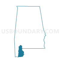
Outline

Summary
| Unique Area Identifier | 521168 |
| Name | Vaughn Community Center |
| County | Baldwin County |
| State | Alabama |
| Area (square miles) | 41.67 |
| Land Area (square miles) | 37.64 |
| Water Area (square miles) | 4.03 |
| % of Land Area | 90.32 |
| % of Water Area | 9.68 |
| Latitude of the Internal Point | 30.97086590 |
| Longtitude of the Internal Point | -87.90495080 |
Maps


Graphs
Select a template below for downloading or customizing gragh for Vaughn Community Center, Baldwin County, Alabama


Neighbors
Neighoring Voting District (by Name) Neighboring Voting District on the Map
- Bay Minette City Hall & Civic Center, Baldwin County, AL
- Crossroads Durant Chapel Church, Baldwin County, AL
- First Baptist Church of Axis, Mobile County, AL
- Mt. Vernon Civic Center, Mobile County, AL
- Stockton Fire House, Baldwin County, AL
- Tensaw Volunteer Fire Dept, Baldwin County, AL
Top 10 Neighboring County Subdivision (by Population) Neighboring County Subdivision on the Map
- Mobile CCD, Mobile County, AL (236,809)
- Bay Minette CCD, Baldwin County, AL (23,604)
- Stockton CCD, Baldwin County, AL (3,804)
Top 10 Neighboring Unified School District (by Population) Neighboring Unified School District on the Map
Top 10 Neighboring State Legislative District Lower Chamber (by Population) Neighboring State Legislative District Lower Chamber on the Map
- State House District 102, AL (50,860)
- State House District 96, AL (50,198)
- State House District 64, AL (40,427)
Top 10 Neighboring State Legislative District Upper Chamber (by Population) Neighboring State Legislative District Upper Chamber on the Map
Top 10 Neighboring 111th Congressional District (by Population) Neighboring 111th Congressional District on the Map
Top 10 Neighboring Census Tract (by Population) Neighboring Census Tract on the Map
- Census Tract 103, Baldwin County, AL (7,826)
- Census Tract 57, Mobile County, AL (7,182)
- Census Tract 101, Baldwin County, AL (3,804)